


The record-breaking tornado activity for 2026 in Illinois is “remarkable,” according to Dr. Trent Ford ’11, who has served the people of Illinois as state climatologist since 2019.
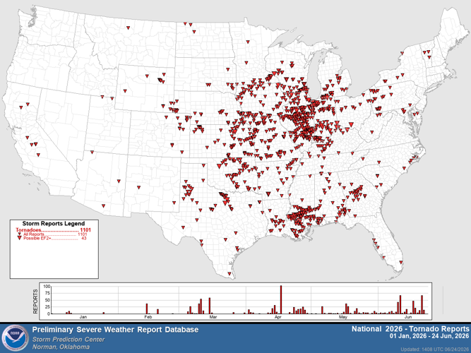
Over the last 30 years, Illinois has averaged 60 tornadoes per year. As of Wednesday, June 24, the National Weather Service confirmed 173 tornadoes have been reported across the state since January 1, the most seen by any state since Texas reported 244 tornadoes in 2015. The previous tornado record in Illinois reached 142 in 2024.
“We have been among the top three or four states, irrespective of the size of the state, in the last four years. This year is particularly remarkable, because not only are we the No. 1 state for tornadoes, but we have over twice as many as the next highest state, which is Mississippi (with 75),” Ford said. “In 2024, we broke the record by quite a large margin, but this year, we shattered that record in June. It’s just absolutely astounding how much this year stands out.”
People are also reading…
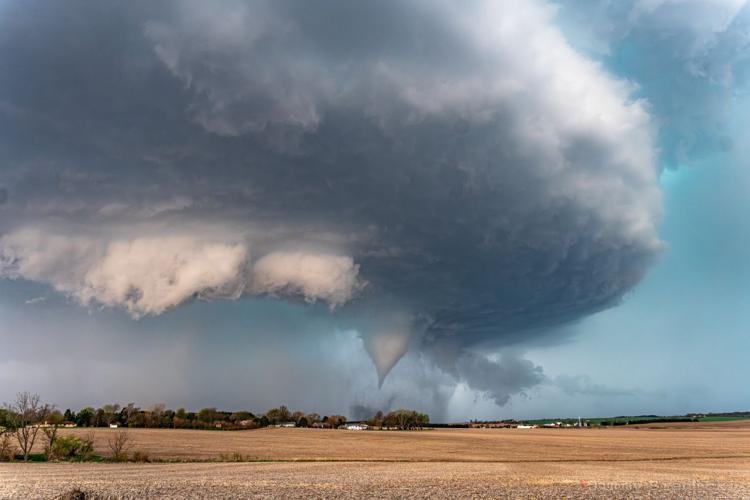
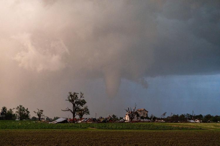
On April 17, a supercell swept through central Illinois, producing damaging winds and hail with tornadoes that touched down in Bloomington-Normal. In June, several rounds of tornadoes spun across southern portions of the state, leaving a destructive path in Effingham and Mt. Vernon.
Because Illinois is oriented north to south in the country, Ford said there is a higher chance for the state to see more tornadoes than centrally formed states. But that does not explain the recent outbreaks.
“In general, when we have really high numbers, so do our neighbors. But this year, although Missouri and Iowa and Indiana are running ahead of average on tornadoes, we have well over double of any of those states,” he said.
Originally from Roanoke, Ford earned a bachelor’s degree in geography at Illinois State University in 2011, followed by a master’s and Ph.D. at Texas A&M University. He is one of only five state climatologists who have served in the Illinois seat since the U.S. Weather Bureau established the positions nationwide in 1954.
Ford offered scientific insight into the state’s whirlwind year of weather and debunked a few popular myths.
What does a state climatologist do?
I am the state’s point person on climate—and sometimes weather, depending on what is going on. I am a climate scientist and I am an employee of the University of Illinois, so I do research on the climate system, especially with water extremes and drought. Being a state climatologist means I also do a lot of outreach and engagement work, assisting state agencies with climate planning and assessments, collecting weather data, and giving talks around the state.
Would you describe this record-breaking year as a sign of what we can expect from future climate cycles?
I am really hesitant to say that it is a sign of a new normal. This is more of a signature of a particular weather pattern that has made it much more likely that we get these big tornado outbreaks, which means it is likely not something that is going to last for the foreseeable future. If we take the signs that understand the science as it is, we will expect a continued increase in tornadoes by the mid- to late-century. However, it is very likely not at the rate that we have seen in the last four years.
What is the leading cause for the increased tornado activity?
Part of the slight increase in tornado frequency that we have seen over the last four years in Illinois may be attributable to climate change, and when we look at projections from our climate models, they show a continued increase in the frequency of those types of environments that can create tornado outbreaks, so climate change does have an effect. But the way that we understand climate change impacts on tornadoes is a developing science. It is not nearly as well developed as it is with droughts or heat waves, where we have a clear signal of climate change as the cause.
I will also add—this is not El Niño, which plays a role in our weather and climate primarily in winter and not for severe weather as much. We talk about an upper-level trough, which is why we have been a little bit cooler for the start of June, and that explains the June 17 and 21 tornado outbreaks, but it does not explain the last four years. As far as what weather phenomenon are causing this, that is an outstanding science question that we are seeking to answer: What are the patterns that have combined to make for this remarkably active period of time that spans over four years?
Is it true that Tornado Alley is shifting east into the Midwest?
People have recognized Tornado Alley as this area of Texas, Oklahoma, Kansas, and Nebraska, and it is reinforced by popular media like Twister, and that is where you go to do storm chasing. But in reality—central and southern Illinois down to parts of Indiana and Kentucky and Mississippi—is also essentially a hot spot for tornadoes. I have a book written in 1998 that shows a map with the number of tornadoes from a 30-year period. What we see is traditional Tornado Alley in red, and then there is a secondary area between eastern Iowa and northern Kentucky that runs right through central Illinois. We have always lived in a sort of tornado alley; it just has not been acknowledged as such.
The little bit of validity that has been exploited for this idea is that slight increase in tornado frequency in our region that we do not see in the Central Plains. So, the idea of it shifting east is the combination of people finally acknowledging the Midwest and the Midsouth for the tornado haven that it is, but also this climate trend occurring over the last couple of decades that has made it so that we are getting a few more tornadoes, while the traditional Tornado Alley may be getting fewer.
Is there any legitimacy to the theory that the geography around Bloomington-Normal protects us in a weather bubble, where the worst of severe weather moves around us?
When I travel around the state, everybody and their dog says they live in a weather bubble. Folks in Chicago think the city is not affected by tornadoes because of a heat island or the lake or whatever it may be. It is simply a matter of blind luck, or the lack of luck, particularly in the case of urban areas. If a tornado is a dart that you are throwing at the dartboard that is Illinois, you are much more likely to hit a rural part of the state than an urban part of the state. There is nowhere in Illinois that has a lesser or higher chance of getting hit by a tornado because of a river or valley or ridge.
What are your thoughts on the growing interest in severe weather, especially through footage that goes viral from storm chasers?
There is a lot of interest in weather for folks who express it by storm chasing, which is certainly a very valid adrenaline high. There are people acting in good faith who try to message about severe weather, but the real professionals are those with the National Weather Service. They are the ones tasked with the responsibility of protecting people, and they are the gold standard for severe weather communication and preparedness.
I would love to see more people become interested in weather and climate to the extent that people are generally interested in and supportive of space science. Investing in weather and climate research is a means of protecting life and property, but we do not necessarily say the same thing with space. We invest all this money to explore, not always for the sake of science. We have this pure science interest in weather and climate that does not have to be grounded in all the bad things that weather brings—but that is sort of the reality of the world.
If people have the opportunity to take an adult learning class or students in college can take a weather and climate class—you will find it absolutely fascinating.
Midwesterners love to sit on the porch to watch a storm roll in. Instead, how should people stay safe, prepare, and be weather aware?
The worst time to think about your severe weather plan is when you are sitting on the porch watching a storm and suddenly it shifts and is coming right at you. The best time to plan is right now, or during relatively calm weather. Make sure your family knows what they should do and where they should go if severe weather is occurring. Get those packs together to be ready for things like extended power outages, with nonperishable food and water. If severe weather is being called for in the evening, make sure your phone is completely charged. Follow messaging from the National Weather Service, and from your local, county, and state emergency managers. They are the ones who have the best interests at heart and are going to be the trusted sources of information. They do tireless, wonderful work.


